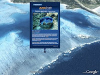
 SEARCH giant Google has launched a new service to let users explore the depths of the world's oceans from the comfort of their homes on dry land.
The "Ocean in Google Earth" feature will allow users to "dive beneath the water surface, explore 3D underwater terrain and browse ocean-related content contributed by marine scientists", Google said.
"Google Earth is equipping itself with a new dimension: depth," Jean-Francois Wassong, an engineer at Google France, said.
Nearly four years after Google Earth enabled users to zoom in to view streets, and later explore galaxies in the sky, the latest version of the software allows virtual travellers to dart across miles of unchartered territory underwater.
"Oceans cover more than 70 per cent of the planet's surface but only a little bit has been explored," said Florence Diss, head of Google's geographical partnerships, referring to findings that humans have examined just 5 per cent of world's seas.
By allowing users to explore underwater volcanoes, hunt for whales and learn more about shipwrecks, Google said the feature offered a platform for everyday people to link up with the scientific community.
The feature includes 20 different layers of content contributed by leading ocean explorers, scientists and researchers, such as photos and videos of "hot spots" around the world and information on marine protected areas.
It also has an animal tracking device in which users can follow animals that have been tagged by satellite.
Ms Diss said the decision to expand Google Earth to cover the world's oceans "is not about making money".
But she would not reveal the project's cost.
Since its launch in June 2005, Google Earth has been downloaded more than 400 million times.
The free software gives internet users access to satellite images and maps around the world.
by:news com.au
Tuesday, February 03, 2009
Subscribe to:
Post Comments (Atom)


